


About the Cover
Vol. 100 No. 2 (2024)
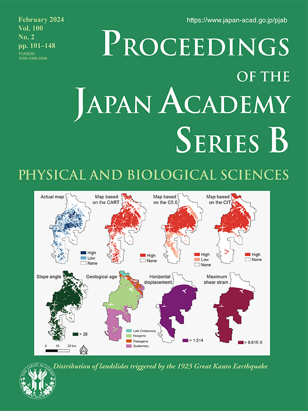
The Great Kanto Earthquake (Magnitude 7.9), which occurred on September 1, 1923, caused extensive disasters, including fires, damage to buildings, and tsunamis. Many buildings in urban areas were destroyed by the strong shaking and resulting fires, and >105,000 residents were dead or missing. Moreover, many landslides were reported mainly in Kanagawa Prefecture. The number of landslides in Kanagawa Prefecture alone amounted to >89,080 and the area amounted to >86.32 km2. This area is equivalent to 7% of the forested area of the prefecture, making this one of the largest slope failure disasters triggered by an earthquake that have occurred since the Meiji era (1868–1912) in Japan.
For this earthquake, detailed landslide distribution maps were published by Kanagawa Prefecture, mainly in mountainous areas, which are said to be the first landslide distribution maps in Japan. This paper analyzes these maps to understand the characteristics of the landslide distribution.
For this purpose, it is important to consider the characteristics of the ground, such as topography and geology, the induced seismic motions, and ground deformation. However, in the case of landslides in the Great Kanto Earthquake, only geomorphology or geology has been considered in previous studies. Endo and Iwahashi in this issue (pp. 123–139) estimated all factors that might have substantially contributed to the distribution of landslides using the decision tree analysis, a statistical analysis technique.
The upper four diagrams of the figure show the original landslide distribution map and results of the three types of decision tree analyses, namely, CART, C5.0, and CIT. These results are compared with the four possible factors, as illustrated by the bottom diagrams of the figure. This comparison clearly illustrates the distribution of landslides in the Tanzawa Mountains. The slope angle was the most significant factor explaining the landslide distribution, followed by the Neogene geological unit, horizontal ground displacement, and the maximum shear strain according to the CART, C5.0, and CIT analyses, respectively.
Yoshio Fukao
Member of the Japan Academy