


About the Cover
Vol. 86 No. 8 (2010)
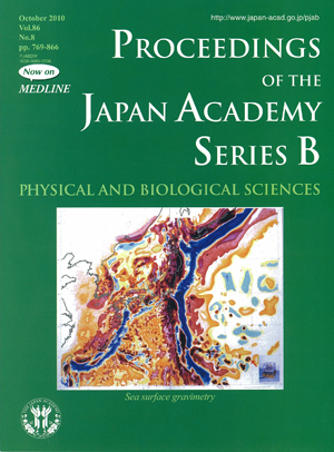
A map of free-air gravity anomalies in the northwestern Pacific compiled and painted in 1982 by the late Prof. Yoshibumi Tomoda, M.J.A. The gravity anomalies in the northwestern Pacific are critical to the understanding of how oceanic plates sink into the deep interior of the Earth, a key process of plate tectonics called “subduction”. Such a vertical motion of materials is associated with large anomalies in mass distribution that can be detected by gravity measurements. Prof. Tomoda developed a unique sea surface gravity-meter and operated it throughout this region (and beyond) to obtain high-resolution gravity anomaly maps such as shown here. Through these high-resolution measurements, Prof. Tomoda and his colleagues discovered that subtle features such as seamounts or faults (transform faults) have large influence on the way in which oceanic plate subducts. These results have important implications for our understanding of fundamental scientific questions such as how plate tectonics occurs but also for practical questions such as how and where submarine earthquakes may occur.
An arrow shows the location of Tomoda seamount named after Prof. Tomoda. It is located to the east of Minami Torishima (Marcus Island). They are part of the Marcus-Wake seamount chain formed during the Cretaceous. Prof. Tomoda investigated the interaction of seamounts and ocean trenches through high-resolution marine gravity measurements.
Research Center for Production of Earthquakes and Volcanic Eruptions, Tohoku University
Shun-ichiro Karato
Department of Geology and Geophysics, Yale University